The Grand Canyon & the Colorado River, Arizona
June 17, 2003: The Little Colorado
All images are the property of Rhett Butler, copyright 2003.
Contact me regarding use and reproduction.
|
|
|
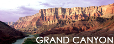
Rafting the Colorado is a fun and exciting way to see one the world's most spectacular natural formations, the Grand Canyon.
Grand Canyon National Park, a World Heritage Site, encompasses 1,218,375 acres and lies on the Colorado Plateau in northwestern Arizona. The land is semi-arid and consists of raised plateaus and structural basins typical of the southwestern United States. Drainage systems have cut deeply through the rock, forming numerous steep-walled canyons. Forests are found at higher elevations while the lower elevations are comprised of a series of desert basins. [National Park Service Excerpt]
|
Recommended travel guides on the Grand Canyon:

Little Colorado River [Wikipedia]:
The Little Colorado River is a tributary of the Colorado River, approximately 315 mi (507 km) long, in the U.S. state of Arizona. The river provides the principal drainage for the Painted Desert.
It rises in eastern Arizona, in southeastern Apache County, and flows northwest, through a series of deep gorges, past the towns of St. Johns, Holbrook, and Winslow. It joins the Colorado in the Grand Canyon, approximately 70 mi (113 km) north of Flagstaff. Stream is dammed, forms Lyman L. (State Park), for irrigation 10 mi/16 km S of St. Johns.
Grand Canyon [Wikipedia]:
previous
Historic exploration of the Grand Canyon
The Spanish
The first documented case of Europeans seeing the Grand Canyon occurred in September of 1540. That year Hopi guides led a group of 13 Spanish soldiers under Captain Garcia Lopez de Cardenas to find the fabled Seven Cities of Cibola for his superior officer, the conquistador Francisco Vasquez de Coronado.
The group arrived at South Rim of the Grand Canyon between Desert View and Moran Point and saw a river below. Pablo de Melgrossa, Juan Galeras and a third soldier descended one third of the way into the Canyon until they were forced to return because of lack of water. It is speculated that their Hopi guides must have been reluctant to lead them to the river, since they must have known routes to the canyon floor. Cardenas greatly underestimated the width of the river below to be 10 feet (3 m). No Europeans visited the canyon for over 200 years.
Fathers Francisco Atanasio Dominguez and Silvestre Velez de Escalante were two Spanish Priests who, with a group of Spanish soldiers, explored southern Utah. The group traveled along the North Rim of the Canyon in Glen and Marble Canyons in search of a route from Santa Fe, New Mexico, to Monterey, California, in 1776.
The Americans
James Ohio Pattie and a group of American trappers and mountain men were probably the next Europeans to reach the Canyon in 1826. There is little in terms of documentation to support this, however.
The signing of the Treaty of Guadalupe Hidalgo in 1848 ceded the Grand Canyon region to the United States. Jules Marcou of the Pacific Railroad Survey made the first geologic observations of the canyon and surrounding area in 1856.
Jacob Hamblin (a Mormon missionary) was sent by Brigham Young in the 1850s to locate easy river crossing sites in the canyon. Building good relations with local Native Americans and white settlers, he discovered Lee's Ferry in 1858 and Pierce Ferry (later operated by, and named for, Harrison Pierce)�the only two sites suitable for ferry operation. George Johnson lead an expedition by stern wheeler steam boat that reached Black Canyon in 1857.
A U.S. War Department expedition led by Lt. Joseph Ives was launched in 1857 to investigate the area's potential for natural resources, to find railroad routes to the west coast, and assess the feasibility of an up-river navigation route from the Gulf of California. The group traveled in a stern wheeler steamboat named Explorer. After two months and 350 miles (560 km) of difficult navigation, his party reached Black Canyon some two months after George Johnson. In the process, the Explorer struck a rock and was abandoned. The group later traveled eastwards along the South Rim of the Grand Canyon.
A man of his time, Ives discounted his own impressions on the beauty of the canyon and declared it and the surrounding area as "altogether valueless", remarking that his expedition would be "the last party of whites to visit this profitless locality". Attached to Ives' expedition was geologist John Strong Newberry who had a very different impression of the canyon. After returning, Newberry convinced fellow geologist John Wesley Powell that a boat run through the Grand Canyon to complete the survey would be worth the risk. Powell was a major in the United States Army and was a veteran of the American Civil War, a conflict that cost him his right forearm in the Battle of Shiloh.
More than a decade after the Ives Expedition and with help from the Smithsonian Institution, Powell led the first of the Powell Expeditions to explore the region and document its scientific offerings. On May 24, 1869, the group of nine men set out from Green River Station in Wyoming down the Colorado River and through the Grand Canyon. This first expedition was poorly-funded and consequently no photographer or graphic artist was included. While in the Canyon of Lodore one of the group's four boats capsized, spilling most of their food and much of their scientific equipment into the river. This shortened the expedition to one hundred days. Tired of being constantly cold, wet and hungry and not knowing they had already passed the worst rapids, three of Powell's men climbed out of the canyon in what is now called Separation Canyon. Once out of the canyon, all three were killed by Shivwits band Paiutes who thought they were miners that recently molested a female Shivwit. All those who stayed with Powell survived and that group successfully ran most of the canyon.
Two years later a much better-funded Powell-led party returned with redesigned boats and a chain of several supply stations along their route. This time, photographer E.O. Beaman and 17-year-old artist Frederick Dellenbaugh were included. Beaman left the group in January 1872 over a dispute with Powell and his replacement, James Fennemore, quit August that same year due to poor health, leaving boatman Jack Hillers as the official photographer (nearly one ton of photographic equipment was needed on site to process each shot). Famed painter Thomas Moran joined the expedition in the summer of 1873, after the river voyage and thus only viewed the canyon from the rim. His 1873 painting "Chasm of the Colorado" was bought by the United States Congress in 1874 and hung in the lobby of the Senate.
The Powell expeditions systematically cataloged rock formations, plants, animals, and archaeological sites. Photographs and illustrations from the Powell expeditions greatly popularized the canyonland region of the southwest United States, especially the Grand Canyon (knowing this Powell added increasing resources to that aspect of his expeditions). Powell later used these photographs and illustrations in his lecture tours, making him a national figure. Rights to reproduce 650 of the expeditions' 1,400 stereographs were sold to help fund future Powell projects. In 1881 he became the second director of the U.S. Geological Survey.
Geologist Clarence Dutton (photo) followed up on Powell's work in 1880�1881 with the first in-depth geological survey of the newly-formed U.S. Geological Survey. Painters Thomas Moran and William Henry Holmes accompanied Dutton, who was busy drafting detailed descriptions of the area's geology. The report that resulted from the team's effort was titled A Tertiary History of The Grand Canyon District, with Atlas and was published in 1882. This and later study by geologists uncovered the geology of the Grand Canyon area and helped to advance that science. Both the Powell and Dutton expeditions helped to increase interest in the canyon and surrounding region.
Prospectors in the 1870s and 1880s staked mining claims in the canyon. They hoped that previously-discovered deposits of asbestos, copper, lead, and zinc would be profitable to mine. Access to and from this remote region and problems getting ore out of the canyon and its rock made the whole exercise not worth the effort. Most moved on, and some stayed to seek profit in the tourist trade. Their activities did improve pre-existing Indian trials, such as Bright Angel Trail.
continued
|