The Grand Canyon & the Colorado River, Arizona
Blacktail Creek Canyon + Elves Chasm
All images are the property of Rhett Butler, copyright 2003.
Contact me regarding use and reproduction.
|
|
|
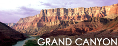
Rafting the Colorado is a fun and exciting way to see one the world's most spectacular natural formations, the Grand Canyon.
Grand Canyon National Park, a World Heritage Site, encompasses 1,218,375 acres and lies on the Colorado Plateau in northwestern Arizona. The land is semi-arid and consists of raised plateaus and structural basins typical of the southwestern United States. Drainage systems have cut deeply through the rock, forming numerous steep-walled canyons. Forests are found at higher elevations while the lower elevations are comprised of a series of desert basins. [National Park Service Excerpt]
|
Recommended travel guides on the Grand Canyon:

Grand Canyon [Wikitravel]:
previous
Protection efforts
By the late 19th century, the conservation movement was increasing national interest in preserving natural wonders like the Grand Canyon. U.S. National Parks in Yellowstone and around Yosemite Valley were established by the early 1890s. U.S. Senator Benjamin Harrison introduced a bill in 1887 to establish a national park at the Grand Canyon. The bill died in committee, but on February 20, 1893, Harrison (then President of the United States) declared the Grand Canyon to be a National Forest Preserve. Mining and logging were allowed, but the designation did offer some protection.
U.S. President Theodore Roosevelt visited the Grand Canyon in 1903. An avid outdoorsman and staunch conservationist, he established the Grand Canyon Game Preserve on November 28, 1906. Livestock grazing was reduced, but predators such as mountain lions, eagles, and wolves, were eradicated. Roosevelt added adjacent national forest lands and redesignated the preserve a U.S. National Monument on January 11, 1908. Opponents such as land and mining claim holders blocked efforts to reclassify the monument as a U.S. National Park for 11 years. Grand Canyon National Park was finally established as the 17th U.S. National Park by an Act of Congress signed into law by President Woodrow Wilson on February 26, 1919. The National Park Service declared the Fred Harvey Company to the official park concessionaire in 1920 and bought William Wallace Bass out of business.
An almost 310 square mile (800 km�) area adjacent to the park was designated as a second Grand Canyon National Monument on December 22, 1932. Marble Canyon National Monument was established on January 20, 1969, and covered about 41 square miles (105 km�). An act signed by President Gerald Ford on January 3, 1975, doubled the size of Grand Canyon National Park by merging these adjacent national monuments and other federal land into it. That same act gave Havasu Canyon back to the Havasupai. From that point forward, the park stretched along a 278 mile (447 km) segment of the Colorado River from the southern border of Glen Canyon National Recreation Area to the eastern boundary of Lake Mead National Recreation Area. Grand Canyon National Park was designated a World Heritage Site on October 24, 1979. [1]
In 1935, Hoover Dam started to impound Lake Mead south of the canyon. Conservationists lost a battle to save upstream Glen Canyon from becoming a reservoir. The Glen Canyon Dam was completed in 1966 to control flooding, provide water and hydroelectric power. Seasonal variations of spring high flow and flooding and low flow in summer have been replaced by a much more regulated system. The much more controlled Colorado has a dramatically reduced sediment load, which starves beaches and sand bars. In addition, clearer water allows significant algae growth to occur on the riverbed, giving the river a green color.
References
In order of greatest use. Prose contains specific citations in source text which can be viewed in edit mode.
- The Grand Canyon, Letitia Burns O'Connor (Los Angeles, California; Perpetua Press; 1992; pages 16-19, 30-32) ISBN 0-88363-969-6
- Secrets in The Grand Canyon, Zion and Bryce Canyon National Parks: Third Edition, Lorraine Salem Tufts (North Palm Beach, Florida; National Photographic Collections; 1998; pages 12-13) ISBN 0-9620255-3-4
- Geology of U.S. Parklands: Fifth Edition, Eugene P. Kiver, David V. Harris (New York; John Wiley & Sons; 1999; pages 395-397) ISBN 0-471-33218-6
- Geology of National Parks: Fifth Edition, Ann G. Harris, Esther Tuttle, Sherwood D. Tuttle (Iowa; Kendall/Hunt Publishing; 1997; page 7) ISBN 0-7872-5353-7
- National Park Service (adapted public domain text) [2] [3] (viewed 17 April 2005; last updated: 6 January 2005)
- American Park Network: Grand Canyon History (viewed 11 April 2005)
Articles involving tourism in the Grand Canyon:
|