
|
New Zealand: Routeburn | Abel Tasman | Queenstown | Other places |
|
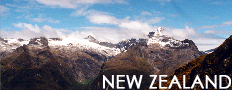
Pictures New Zealand - Index
|
|||||||||||
|
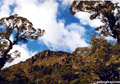
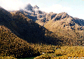
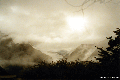
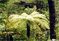
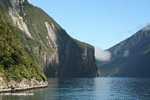
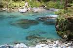
Recommended travel guides on New Zealand: New Zealand [Wikipedia]: New Zealand is an island nation-state in the south-western Pacific Ocean. The country consists of two major islands and a number of smaller islands. A popular Maori name for New Zealand is Aotearoa, often translated as The Land of the Long White Cloud. New Zealand is a parliamentary democracy and a Commonwealth Realm. New Zealand is responsible for the self-governing states of the Cook Islands and Niue and administers Tokelau and the Ross Dependency. New Zealand is the most geographically isolated country in the world. Its closest neighbor, Australia, is 2,000 km to the north-west of the main islands, across the Tasman Sea. The only significant landmass to the south is Antarctica; to the north are New Caledonia, Fiji and Tonga. History New Zealand is one of the most recently settled major land masses. Polynesian settlers arrived in their waka some time between 1500 and 600 years ago to establish the indigenous Maori culture. Settlement of the Chatham Islands to the south-east of New Zealand produced the Moriori people but is uncertain whether they moved there from New Zealand or Polynesia. New Zealand was divided into tribal territories called rohe, each controlled by an iwi, with no two iwi having overlapping territories. Maori adapted to eating the local marine resources, flora and fauna for food, hunting the giant flightless Moa to extinction, and ate the Polynesian Rat and sweet potato called kumara which they introduced to the country. The first Europeans known to reach New Zealand were led by Abel Janszoon Tasman, who sailed up the west coast of the South and North islands in 1642. He named it Staten Landt, believing it to be part of the land Jacob Le Maire had discovered in 1616 off the coast of Chile. Staten Landt appeared on Tasman's first maps of New Zealand, but this was changed by Dutch cartographers to Nova Zeelandia, after the Dutch province of Zeeland, some time after Hendrik Brouwer proved the South American land to be an island in 1643. The Latin Nova Zeelandia became Nieuw Zeeland in Dutch. Lieutenant James Cook subsequently called the islands New Zealand. Cook began extensive surveys of the islands in 1769, leading to European whaling expeditions and eventually significant European colonization. From as early as the 1780s, Maori had encounters with European sealers and whalers. Acquisition of muskets by those tribes in close contact with European visitors destabilized the existing balance of power between Maori tribes and there was a temporary but intense period of bloody inter-tribal warfare, known as the Musket Wars, that only ceased when all tribes were so armed. French interest in the region led the British to negotiate the Treaty of Waitangi of 1840, making New Zealand a British colony. The treaty promised the Maori tribes "tino rangatiratanga". This phrase, translated as "chieftainship" by the British, more accurately means "sovereignty" in Maori. Treaty violations by the British were the cause of the New Zealand land wars which took place between 1845 and 1872. In 1975 the Treaty of Waitangi Act established the Waitangi Tribunal, charged with hearing claims of Crown violations of the Treaty of Waitangi dating back to 1840. Although New Zealand was initially administered as a part of the Australian colony of New South Wales, it became a colony in its own right in 1841. Self-government was granted to the settler population in 1852. The first capital of New Zealand was Kororareka (known today as Russell) but shortly afterwards moved to Auckland. There were political concerns following the discovery of gold in Central Otago in 1861 that the South Island would form a separate colony. So in 1865 the capital was officially moved to the more central city of Wellington. New Zealand was involved in a Constitutional Convention in March 1891 in Sydney, New South Wales, along with the then-colonies of Australia. This was to consider a potential constitution for the proposed federation between the then-British Colonies of Australasia. New Zealand lost interest in joining Australia in a federation following this convention. New Zealand became an independent dominion on 26 September 1907 by royal proclamation. Full independence was granted by the United Kingdom Parliament with the Statute of Westminster in 1931; it was taken up upon the Statute's adoption by the New Zealand Parliament in 1947. Since then New Zealand has been a sovereign constitutional monarchy within the Commonwealth of Nations. Geography New Zealand comprises two main islands and a number of smaller islands. The total land area of New Zealand, 268,680 km�, is somewhat less than that of Japan or of the British Isles, and slightly larger than Colorado in the USA. The country extends more than 1600 km along its main, north-north-east axis. The most significant inhabited islands of New Zealand include Stewart Island/Rakiura, Waiheke Island, an island in Auckland's Hauraki Gulf, Great Barrier Island, east of the Hauraki Gulf and the Chatham Islands, named Rekohu by Moriori. The country has extensive marine resources, it has the fourth largest Exclusive Economic Zone in the world covering over 4 million km�, more than 15 times the land mass.[2] The South Island is the largest land mass, and is divided along its length by the Southern Alps, the highest peak of which is Aoraki/Mount Cook, at 3,754 meters. There are 18 peaks of more than 3,000 meters in the South Island. The North Island is less mountainous than the South, but is marked by volcanism. The tallest North Island mountain, Mount Ruapehu (2,797 meters), is an active cone volcano. The dramatic and varied landscape of New Zealand has made it a popular location for the production of television programs and films, including the Lord of the Rings trilogy. The usual climate throughout the country is mild, mostly cool temperate to warm temperate, with temperatures rarely falling below 0�C or rising above 30�C. Conditions vary from wet and cold on the West Coast of the South Island to dry and continental in the Mackenzie Basin of inland Canterbury and subtropical in Northland. Of the main cities, Christchurch is the driest, receiving only some 500 millimeters of rain per year. Auckland, the wettest, receives a little less than three times that amount. Flora and fauna Because of its long isolation from the rest of the world, and its island biogeography New Zealand has extraordinary flora and fauna. About 80 per cent of the New Zealand flora only occurs in New Zealand, including more than 40 endemic genera.[3] The main two types of forest have been dominated by podocarps including the giant kauri and southern beech. The remaining vegetation types in New Zealand are grassland of grass and tussock, usually associated with the subalpine areas, and the low shrublands between grasslands and forests. Until the arrival of the first humans, 80% of the land was forested and, barring two species of bat, there were no non-marine mammals at all. Instead, New Zealand's forests were inhabited by a diverse range of birds including the flightless Moa which is now extinct, the Kiwi, Kakapo, and Takahe which are all endangered due to the human actions. Unique birds capable of flight include the Haast's eagle which was the world's largest bird of prey before it became extinct and the large parrots the Kaka and Kea. Reptiles present in New Zealand include skinks and geckos and the Tuatara, there are no snakes, there are also many species of insects — including the weta which may grow as large as a House Mouse. Travel SHARE: |
what's new | rainforests | tropical fish | for kids | search | about | copyright & use | contact |
Copyright Rhett Butler 1994-2012 Pictures were taken by Rhett A. Butler, copyright 1996-2009. While these photos are the property of mongabay.com, it may be permissible to use them for non-commercial purposes (like powerpoint presentations and school projects), provided that the images are not altered in any form. Please read this for more details. If you are interested in using an image in a publication please contact me. Mongabay.com is a free resource. |