The Grand Canyon & the Colorado River, Arizona — INDEX
All images are the property of Rhett Butler, copyright 2003.
Contact me regarding use and reproduction.
|
|
|
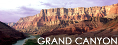
Rafting the Colorado is a fun and exciting way to see one the world's most spectacular natural formations, the Grand Canyon.
Grand Canyon National Park, a World Heritage Site, encompasses 1,218,375 acres and lies on the Colorado Plateau in northwestern Arizona. The land is semi-arid and consists of raised plateaus and structural basins typical of the southwestern United States. Drainage systems have cut deeply through the rock, forming numerous steep-walled canyons. Forests are found at higher elevations while the lower elevations are comprised of a series of desert basins. [National Park Service Excerpt]
|
Recommended travel guides on the Grand Canyon:

Grand Canyon [Wikitravel]:
The Grand Canyon is a colorful, steep-sided gorge, carved by the Colorado River, in northern Arizona. The canyon is one of the seven natural wonders of the world and is largely contained in the Grand Canyon National Park � one of the first national parks in the United States. President Theodore Roosevelt was a major proponent of the Grand Canyon area, visiting on numerous occasions to hunt mountain lions and enjoy the breathtaking scenery.
The canyon, created by the Colorado River cutting a channel over millions of years, is about 277 miles (446 km) long, ranges in width from 4 to 18 miles (6 to 29 kilometers) and attains a depth of more than a mile (1,600 m). Nearly 2000 million years of the Earth's history has been exposed as the Colorado River and its tributaries cut through layer after layer of sediment as the Colorado Plateaus have uplifted.
The Grand Canyon was first seen by a European in 1540, Garc�a L�pez de C�rdenas from Spain. The first scientific expedition to the canyon was led by U.S. Major John Wesely Powell in the late 1870s. Powell referred to the sedimentary rock units exposed in the canyon as "leaves in a great story book." However, long before that, the area was inhabited by Native Americans who built settlements in the canyon walls.
Geography
The Grand Canyon is a very deep - in places even a mile deep - 277 mile (446 km) long cut in the Colorado Plateaus that exposes uplifted Proteozoic and Paleozoic strata. The exposed strata are gradually revealed by the gentle incline beginning at Lee's Ferry and continuing to Phantom Ranch. At the point where the river crosses the Grand Wash Fault (near Lake Mead) the Canyon ends.
Uplift associated with plate tectonics-caused mountain building events later moved these sediments thousands of feet upward and created the Colorado Plateaus. The higher elevation has also resulted in greater precipitation in the Colorado River drainage area, but not enough to change the Grand Canyon area from being semi-arid. Landslides and other mass wasting events then caused headward erosion and stream capture - all of which tend to increase the depth and width of canyons in arid environments.
The uplift of the Colorado Plateaus is uneven, resulting in the North Rim of the Grand Canyon being over a thousand feet (about 300 meters) higher than the South Rim. The fact that the Colorado River flows closer to the South Rim is also explained by this asymmetrical uplift. Almost all runoff from the plateau behind the North Rim (which also gets more rain and snow) flows toward the Grand Canyon, while much of the runoff on the plateau behind the South Rim flows away from the canyon (following the general tilt). The result is much greater erosion and thus faster widening of the canyon and its tributary canyons north of the Colorado River.
Temperatures on the North Rim are generally lower than the South Rim because of the greater elevation (8000 feet/2438 m above sea level). Heavy snowfall is common during the winter months. Views from the North Rim tend to give a better impression of the expanse of the canyon rather than the views down which characterize the South Rim.
The Havasupai Indian Reservation is in a large tributary canyon on the south side of the Colorado River; it is administered by the Havasupai Indian Tribe.
continued
|