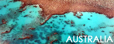
Pictures of the Daintree Rainforest in Australia
All images are the property of Rhett Butler. Contact me with questions regarding use, reproduction, or purchase of any of the pictures.


Recommended travel guides on Australia:
Daintree National Park -- from Wikipedia
Daintree is a national park in Far North Queensland (Australia), 1502 km northwest of Brisbane and 100 km northwest of Cairns. It was founded in 1988, when it also was nominated for the World Heritage List.
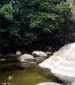
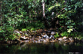
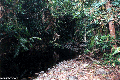
Much of the national park is covered by rainforest. The Greater Daintree Rainforest has existed continuously for more than 110 million years, making it possibly the oldest existing rainforest.
The park is the location of the bouncing stones Aboriginal site.
Area: 7080 km�
Date of establishment: 1988
Richard Daintree (13 December 1832 � 20 June 1878) was a pioneering Australian geologist and photographer. In particular, Daintree was the first Government geologist for North Queensland discovering gold fields and coal seams for future exploitation. Daintree was a pioneer in the use of photography during field trips and his photographs formed the basis of Queensland's contribution to the Exhibition of Arts and Industry in 1871. Following the success of the display, he was appointed as Queensland's Agent-General in London in 1872 but was forced to resign in 1876 due to ill-health and malpractice by some of his staff although not Daintree himself. A number of features in North Queensland have been named after Daintree including the town of Daintree, Queensland, the Daintree National Park, the Daintree River, the Daintree Rainforest which has been nominated for the World Heritage List and the Daintree Reef.
[an error occurred while processing this directive]
|