
|
Argentina: Perito Moreno | Perito Moreno | Upsala | Igauzu Falls |
|
|
| ARGENTINA Glaciers | Glaciers II | Ice bergs |
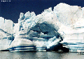
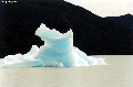
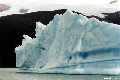
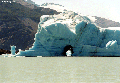
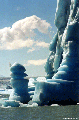
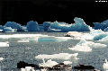
Ice Bergs at Upsala
Except where noted, all images are the property of mongabay.com, copyright 1994-2004. Contact me with questions regarding use, reproduction, or purchase of any of the pictures.
|
Recommended travel guides on Argentina:

Patagonia [Wikipedia]:
- Neuqu�n, covering 94,078 km� (36,324 sq. miles), including the triangle between the rivers Limay and Neuquen, and extending southward to the northern shore of Lake Nahuel-Huapi (41�S) and northward to the Rio Colorado;
- R�o Negro, covering 203,013 km� (78,383 sq. miles), extending from the Atlantic to the Cordillera of the Andes, to the north of 42�S;
- Chubut, covering 224,686 km� (86,751 sq. miles), embracing the region between 42� and 46�S; and
- Santa Cruz, which stretches from the last-named parallel as far south as the dividing line with Chile, and between Point Dungeness and the watershed of the Cordillera: an area of 243,943 km� (94,186 sq. miles).
SHARE:
what's new | rainforests | tropical fish | for kids | search | about | copyright & use | contact |
Copyright Rhett Butler 1994-2012 Pictures were taken by Rhett A. Butler, copyright 1996-2009. While these photos are the property of mongabay.com, it may be permissible to use them for non-commercial purposes (like powerpoint presentations and school projects), provided that the images are not altered in any form. Please read this for more details. If you are interested in using an image in a publication please contact me. Mongabay.com is a free resource. |